BFI MARITIME DIRECTORY
.png)
%20(1).png)
SEARCH
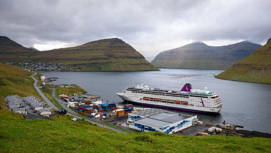
Port of Klaksvík

Website: Port of Klaksvik
Phone: (+298) 45 50 81
Email: port@klaksvik.fo
Website: www.portofklaksvik.fo
With deep-water berths, comprehensive cargo handling facilities, and a dedicated ferry terminal, the port is capable of accommodating a wide range of vessels, from fishing trawlers to cargo ships and passenger ferries. The facilities are designed for efficiency, safety, and environmental responsibility, with sustainable practices in place to protect the stunning natural environment surrounding the port.

Nestled in the scenic landscape of Klaksvík, the second-largest town in the Faroe Islands, the Port of Klaksvík serves as a vital hub for maritime trade, fishing, and transport in the North Atlantic. With a rich history and a strategic location, the port is at the center of the islands' thriving fishing industry and serves as a key gateway for goods and services connecting the Faroe Islands to the rest of the world.
Connectivity and services
Strategically located on the island of Borðoy, Klaksvík is well-connected to other towns in the Faroe Islands and to international markets. The port serves as a critical link for both passenger ferries and freight, ensuring the smooth transport of goods and people throughout the region. Visitors can also enjoy stunning views of the surrounding mountains, fjords, and traditional Faroese architecture, making it a memorable stop for those traveling through the islands.
Qays
North Quay
317 meter quay, depth alongside 12 meters; ro-ro ramp 30 meters wide; high-pressure disinfected water supplies through 6” tubes (450.000 litres/hrs.). ISPS approved terminal.
(Credit: portofklaksvik.fo)
West Quay
Dedicated terminal for container ships, general cargo, fish landing and cruise ships. There are 300 metres of quay with a depth alongside of 8.75 metres. Maximum length of ship 160 metres LOA..

(Credit: portofklaksvik.fo)
Kósin Quay
Dedicated terminal for fish landing and general cargo. The terminal has a total quay length of 267 metres, with a depth alongside of 8 metres. Maximum length of ship 180 metres LOA.

(Credit: portofklaksvik.fo)
Fuel Quay
Tanker terminal with a quay length of 55 metres including a dolph albue. The quay has a depth alongside of 8 metres and tankers up to 6000 tonnes can be handled.

Port facilities
Airport:
Access to airport 1 hour away with regular flights to Denmark, Norway, Scotland, Iceland and Greenland.
Anchorage:
There is excellent anch orage with a firm sea bed and a depth of 35-45 metres on the well sheltered Pollurin (Roads), in the lee of Kunoy Island. Distance from the harbour is 800 metres.
Approach:
The main entrance to the Port of Klaksvík is from the NW between Kunoy and Klakkur. Thanks to the effects of nature, the harbour is the safest and best sheltered in the Faroe Islands. The approach to the harbour is very good and the sailing route from both north and south is deep and clearly marked. There are no restrictions and the harbour is ice-free all year round.
Bunkering:
Fuel and diesel are available from Shell and Statoil at the Fuel Quay and from road tankers at all piers throughout the harbour area.
Location:
Latitude: 620 14´ N, Longitude: 0060 35´ W
Locode
FOKVI
Medical facilities:
A modern 40 bed hospital is located in Klaksvík with a medical and surgical department, and furthermore a special department for orthopedic surgery.
North quay
317-meter quay, depth 12 meters. ISPS approved terminal.
Office:
Harbour Office: +298 215081
Radio information 24-hour VHF communications: Channel 12 and 16.
Pilotage
Pilotage is required for vessels larger than 500 GRT, and for ships with dangerous goods.
Port agent:
Port agent Faroe Ship +298 349000 agency@faroeship.fo
Tor Shipping +298 359531 torship@torshipping.fo
North West Chartering +298 236020 nwc@nwc.fo
Faroe Agency +298 351990 faroeagency@faroeagency.fo
Faroe Maritime Services +298 610000 fms@fms.fo
Services:
Stores, bunkers, repairs, bonded stores, clearance, local custom office.
Ship Repair:
The shipyard has a slipway with a capacity up to 800 tonnes and all types of facilities are available, including modern mechanical and electronic workshops.
Storage:
There are 48,000 square metres of open storage, 10,000 cubic metres of cool storage and 24,000 cubic metres of cold storage.
Tides:
The local tidal range is 1.2 metres maximum, and does not hinder or influence port operations.
Waste and water:
Waste disposal services are available on request from the Port Authority.
Fresh water and electricity are available at all piers from the shore installations. Provisions, ice and salt are all available.
West quay
165 meter quay, depth 8 meters.
Vikmar live vessel tracker
(Credit: Vikmar.fo official vessel real-time tracking map)
LATEST NEWS


